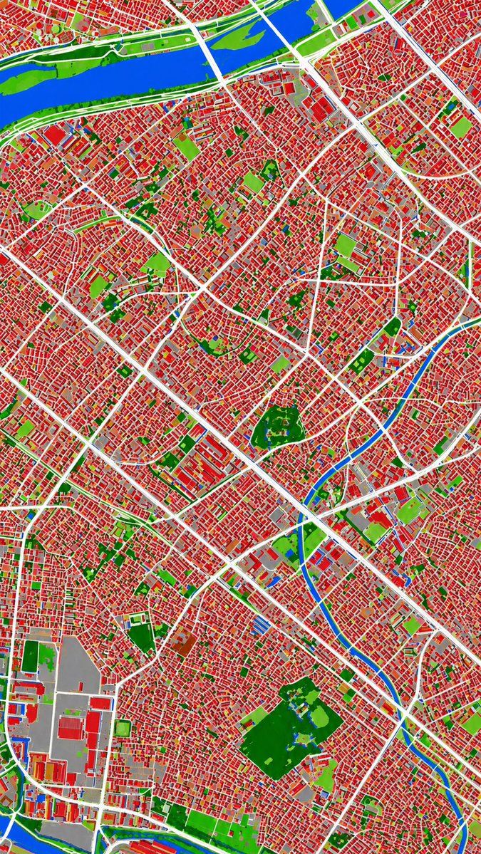
Aerial Photo to Land-Cover Map
This prompt converts a reference aerial photograph into a false-color land-cover classification map for urban analysis or map-style visualization.
适合做图解、清单、路线图和知识长图:先锁定信息层级,再把文字量控制在模型能稳定处理的范围里。
画幅建议
16:9 或 4:3
细节策略
先快速出图,再细节精修
生成流程
需要贴合参考图或既有版式时,用图生图;其他情况先用文字生成定方向。
完整 GPT Image 2 提示词
English prompt
Using REFERENCE_0 as the source geography and urban layout, transform the monochrome historical aerial photo into a clean land-cover classification map using the false-color visual language implied by REFERENCE_1. Keep the same top-down viewpoint and street/block structure, but replace photographic texture with flat segmented regions and crisp boundaries. Classify the scene into exactly 6 visual categories: 1) buildings as red, 2) roads and major paved corridors as white, 3) water bodies and canals as blue, 4) dense vegetation/parks as dark green, 5) open grass or sparse green areas as light green, and 6) industrial or large paved/open facility areas as gray. Produce a dense urban thematic map with strong contrast, minimal shading, and no labels, legends, borders, or photographic film markings.
相关 GPT Image 2 提示词
VR Headset Exploded View Poster
Generates a high-tech exploded view diagram of a VR headset with detailed component callouts and promotional text.
Illustrated City Food Map
Generates a hand-drawn, watercolor-style tourist map featuring numbered local food specialties, landmarks, and a legend.
3D Stone Staircase Evolution Infographic
Transforms a flat evolutionary timeline into a realistic 3D stone staircase infographic with detailed organism renders and structured side panels.
Momotaro Explainer Slide in Hybrid Style
A prompt that combines the simple, warm aesthetic of simple illustration style illustrations with the high-information density characteristic of Japanese government slides.
Faceless Cyberpunk Infiltrator
Generates a cinematic anime scene of an armed faceless woman infiltrating a high-security futuristic server room.
Pancake Angel Cafe Cover
Generates a dreamy watercolor anime cover of a winged cafe angel serving honey pancakes in a sunlit morning cafe.